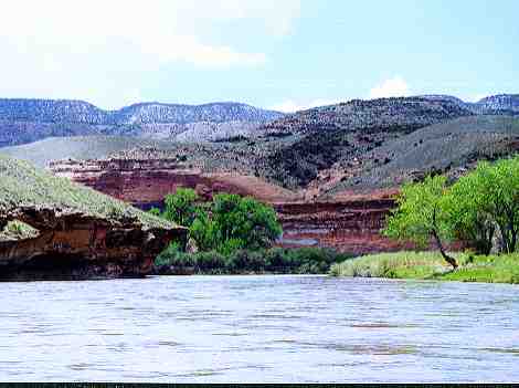
From Delta to the dam at Grand Junction is 46 miles of canyon wilderness that is perfect for canoes, kayaks, and rafts. The run can be divided into four nearly equal lengths as determined by the river access points which are: 1. Delta's Confluence Park, 2. the bridge at Escalante, 3. Bridgeport Road, 4. the Whitewater boat access, and 5. the Redlands Power dam. Each segment is about 13 miles. Each segment takes from 1 hour and 20 minutes to 3 hours and 30 minutes to paddle or float depending of the water level and how hard you paddle or easy you float. When the southwest spring winds are strong headwinds on the Colorado and the Green, these winds are tailwinds on the Gunnison River. An additional bonus of paddling the Gunnison is that there is no motorized boat access on the Gunnison at the dam at Grand Junction all the way up to Escalante, a distance of 35 miles. Your chances of encountering motor boats or jet skis are minimal.
An excellent account of a trip from Delta to Grand Junction in April 2002 by Marek Uliasz is posted on his website.
BLM regulations require all floaters to carry and use a firepan $25.00, also called an oil drain pan $3.79, and a portable toilet system sometimes called a "groover".
The area surrounding the Gunnison River described below as Sections 2 through 4 include areas that are being considered for National Conservation Area (NCA) status. Dominguez and Escalante canyons are included in the area. Dominguez Canyon is currently a Wilderness Study Area (WSA). As a preliminary step to moving to NCA status a "Dominguez-Escalante Community Education Forum" was held on June 14, 2007.